The Making of a Plan: More than the Sum of its Parts
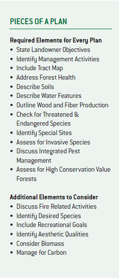
 The ATFS Standards identify a short list of elements for
inclusion in every forest management plan, as well as elements to be
incorporated where appropriate (see sidebar). First, there are elements that
are observed about the property. Second, there are elements that other sources
or authorities, such as state agencies, help to identify. Third, there are
elements that the landowner and forester identify and create, based on those
observations. Finally, there is the map.
Starting with the first category, the plan should provide
the landowner’s contact information, the location of the Tree Farm and a
general overview of on-the-ground conditions, identifying significant features
of the property. This information includes general accounts of the timber
resources, water features on the property, general soil types and a synopsis of
the forest’s health, noting any current or anticipated insect and disease
concerns.
Next, there are key
elements that require external consultation, including threatened and
endangered species, special sites and high conservation value forests.
Information about threatened and endangered species can be gleaned from state
agencies or the U.S. Fish and Wildlife Service using their online databases.
Similarly, you can contact state historic preservation offices and state
cultural and natural heritage programs or consult their online databases for
information about known special sites with cultural, historic, biological and
other significant values. High conservation value forests (HCVF) are forests of
outstanding or critical importance due to their environmental, social or
biodiversity values. These unique forests systems are landscape-scale
representations and are, thus, unlikely to occur on a Tree Farm. However,
review of the resources used to verify special sites should also be used for
consultation for HCVF. The information gathered about all of these resources
can be used in tandem with insights that landowner has about the property to ensure
each element is documented in the plan, even if these resources are not present
on the Tree Farm.
Next, the forester and landowner work together to set out a
management strategy. This starts with the landowner’s objectives. These can be concise
statements about what the landowner hopes to accomplish. For example, a
landowner may wish to create high quality turkey habitat for hunting, generate
some income and use the property for cross-country skiing in the winter. You
can work with the landowner to identify the desired forest conditions that
correspond to those goals and a strategy to achieve them.
Be sure to include the range of techniques that will be
considered and used. For example, if there is an insect outbreak on the
property, make note of the management practices for preventing or controlling
the outbreak. You should also refer to any relevant laws in management
activities. For example, where water features are present on the property or
harvesting and road building activities are planned, citing that Best
Management Practices are a part of the management implementation demonstrates
strong understanding of the laws, as well as the ATFS Standards.
Finally, property maps should include boundaries and accurately depict significant forest resources, including water features, roads and any special sites identified. Maps should also reflect the size, scale and intensity of the property and management, adding stands and other details, as appropriate for the site.


